I have waited over a year and a half to finally get out for an adventure—in normal times an annual occurrence—because of the ineptitude and calumny of the Trumpers of the world, who have prolonged this pandemic isolation by ignoring science. No one really expected this ecologically inevitable pandemic to persist well into 2021, but here we are, now fighting an unnecessary Covid variant. So while it's still not really safe out there, backpacking with a couple other fully vaccinated hikers seemed doable. I was fortunate that my Colorado backpacking pals Joel and John were available and up for a challenge.
Joel and John are long-time hiking-biking partners. They've spent decades bike touring across the U.S., from north to south, east to west, and many routes in-between. They've also backpacked all over Colorado and adjacent states, including tackling numerous fourteeners during their seven-plus decades on this orb. I always learn a lot with them, whether biking or backpacking, and this time would be no exception.
I did a little research on possible hikes and one route kept popping up as worthy of it's "difficult" designation, with scenery worthy of three days of arduous effort: the Lost Creek Wilderness Loop in the Pike-San Isabel National Forests & Cimarron and Comanche National Grasslands. And that's what you get on this hike: mountains, forests, and grasslands.
According to the US Forest Services website:
Lost Creek Wilderness was officially designated by the Colorado Wilderness Act of 1980 with additions in 1993. Today it totals 119,790 acres. Elevations range from 8,000' to 12,400' above sea level. Lost Creek was named after a creek of the same name that repeatedly disappears undergound only to reappear again further downstream where it ultimately becomes Goose Creek.
Lost Creek is accessed by a 136 mile trail network, 105 miles of which are within the Wilderness boundary. The trail system traverses tree-lined mountain parks, fascinating rounded granite domes, and rare granite arches. Black bears, bighorn sheep, deer, elk, and bobcats share the region. Vegetation includes ponderosa, bristlecone, and lodgepole pine, aspen, spruce, fir, and alpine tundra.
 |
One thing I looked for in choosing a route was elevation gain and overall distance. I wanted something we could knock out over three days, a challenging route but one I knew we could tackle. My reference point was a hike Joel and I did in 2019 on the Pine Creek Trail near Buena Vista, Colorado. The Pine Creek Trail has a similar day-one elevation gain. Pine Creek was also a tad shorter, 26 miles vs. 28 (or so I thought. This hike proved to be closer to 32). The primary difference between them, is that the Pine Creek trail is gradual, with smooth footing, and a "moderate" hike designation; Lost Creek, by contrast, is alternately flat and extremely steep, with many slippery, talus-covered, and rocky footpaths that make it well deserving of its designation as a hard trail.
|
 |
Joel, uber fit and ready to tackle any challenge, despite his recent foot problems.
|
 |
John, recovered from a leg injury that kept him off the trails for three years, eager to get back out there.
|
 |
The hike starts and ends in a beautiful valley, with a cushy, sand and gravel strewn footbed.
|
 |
Most hikers recommend hiking this loop counter-clockwise so as to climb the challenging Bison Peak on fresh legs. What few people mention is that the second day is arguably more challenging, albeit shorter than the first. Good thing the last day is flat for the final eight miles.
|

 |
| Trail marker on the first leg where the Brookside-McCurdy Trail makes a hard left at the Ute Creek Trail. This is where I waited for John and Joel after the first stretch, and also where I left my sunglasses behind—a gift for the next hiker. This is likewise where the trail took a turn for the upward and the steep. |
 |
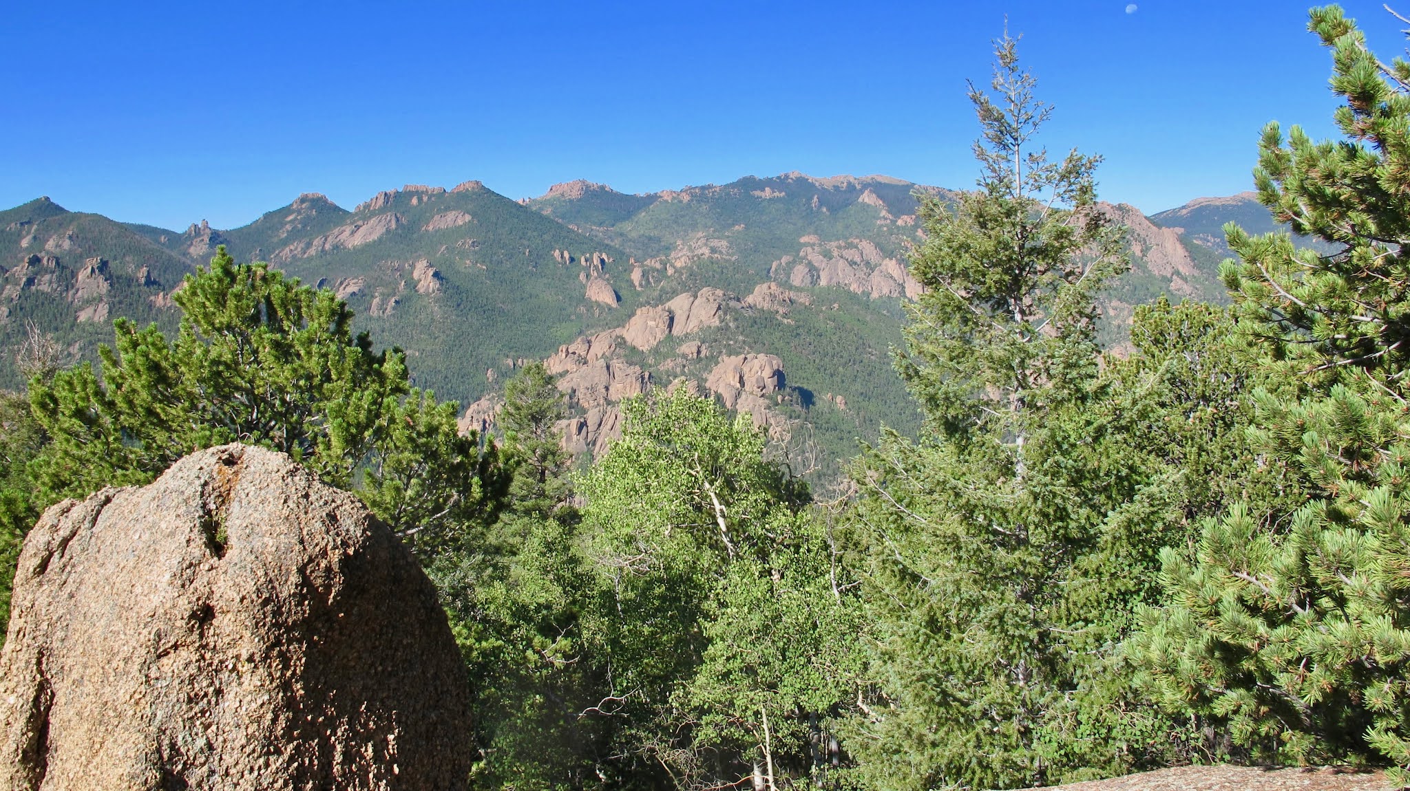
A hint of our granite future.
|
 |
The reward for climbing to the upper reaches of Bison and McCurdy peaks is the 360º views. Simply stunning.
|
 |
Slippery scree made hiking poles a necessity on parts of this trail. Beautiful weather, but almost hot in the 75º sun.
|
 |
| John and Joel catching up, John palpably expressing how we all felt after the initial leg up. |
 |
Lots of rock outcroppings and scattered boulders in this section. Again, a most-varied topography and geology.
|
 |
On the front side of Bison Peak, a field of corpses from the last fire that torched the area, and based on the remains and the new growth, about 15-20 years ago.
|
 |
One of many stone sentries futilely keeping fire watch.
|
 |
A formidable tranche of granite, the result of volcanic activity millions of years ago (or 6,000 years ago if you're a Trumper believer in the literal BuyBull®.

Just a relatively short trip down the McCurdy-Brookside to the McCurdy Park Trail that will take us the mile to water and our campsite.
|
 |
Our campsite for night one (shot taken the following morning). We got in at a dusky 7:00 pm, filtered some water, set up our tents and crashed, sans dinner. We made up for that slight with dinner for breakfast the following morning. And morning didn't come soon enough, with nighttime temps in the thirties. Shoulda brought the down sleeping bag.
|
 |
Day two would prove to be quite challenging as we negotiated a very rocky topography, more slippery scree, and one short stream crossing. We had to get to the 16.5 mile mark where we were assured there would be water.
|
 |
Just before the water, at the 16.5 mile mark as we had hoped, and as is usual where there is water, there is a wonderful campsite, this one in an aspen grove with a stunning red rock background. We decided to make a short day of it and enjoy the moment—and the digs—and stay for the night. We were happy to be encamped by 2:30 in the afternoon, plenty of time to loaf and explore.
|
 |
Backdrop to our temporary mobile home park.
|
 |
View out the window of my old (2005) MSR Hubba Hubba tent.
|
 |
Dramatic sunset only matched by the sunrise on the red rocks behind us the following morning. We were in our tents before sunset, and around midnight, thunder and lightening heralded a downpour of rain that lasted well over an hour. We managed to gather all our gear into our tents beforehand, however, and everyone remained dry for the duration.

Hard to see in this picture, but the granite amalgam making up the boulders on which we rested was quite rough and sharp, and needless to say, pretty uncomfortable. It was also pretty capable of ripping through a pair of nylon hiking pants as you will see in the next frame.
|

 |
| The climb out of our little campsite was about two miles, but it was a cool morning, the trail had a nice smooth foot bed, and the ascent was not too steep. We did have about five false summits—this being the first—but the overall feeling was that the worst was over. This would be a long day at over 12 miles, but it wouldn't kill us with challenging terrain. |
 |
| At the second false summit, we intersect the Goose Creek Trail, which we will take three miles to the left to meet up with our final trail, the Wigwam Creek Trail with will take us the final five or six miles back to the trailhead. |
 |
| Feeling good after the morning's climb, which was almost over, and ready for the last eight miles. |
 |
A veritable freeway.
|

 |
| As I told Joel and John after the climbing of days one and two, day three would be a walk in the park. |
 |
| One last shot of the dramatic valley we began and ended in. |
 |
| Waiting at the trailhead for John and Joel in the sputtering drizzle. |
 |
| And here they are, relieved, still upright, and ready for the half-mile hike back to the truck. |
Other Photographs


 I have waited over a year and a half to finally get out for an adventure—in normal times an annual occurrence—because of the ineptitude and calumny of the Trumpers of the world, who have prolonged this pandemic isolation by ignoring science. No one really expected this ecologically inevitable pandemic to persist well into 2021, but here we are, now fighting an unnecessary Covid variant. So while it's still not really safe out there, backpacking with a couple other fully vaccinated hikers seemed doable. I was fortunate that my Colorado backpacking pals Joel and John were available and up for a challenge.