

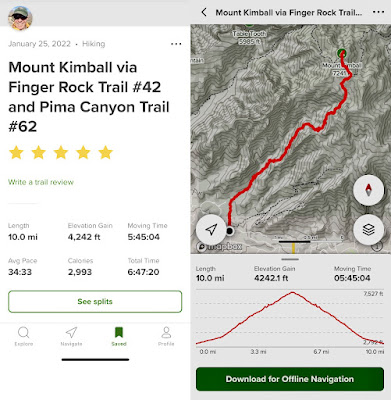
I have hiked to Mount Kimball previously, in 2019 with my hiking partners Jack and Misty. That was a point-to-point hike coming up Pima Canyon Trail and coming down Finger Rock Trail—arguably easier despite being longer because of the steepness and rockiness of the Finger Rock Trail compared to Pima Canyon, which is itself steep and rocky.
And this wasn't my first ascent of the Finger Rock Trail. I hiked it up to Linda Vista Saddle twice, in 2018 when it was wet and treacherous, and again in 2019. We saw no hikers past Linda Vista Saddle, and very few before, except in the last mile on our return. The trail is still listed as closed on AllTrails so that probably cut down on the more serious hikers.
 |
The gods decided to highlight Finger Rock as I approached the parking lot at the end of Algernon Way. |
 |
A closeup of the offending digit. |
 |
The trail starts out with a stream crossing or two and a nice flat trail surface. After about a mile in, however, it really gets steep. |


 |
Linda Vista Saddle, about 3 miles in. |
 |
The intersection with Pima Canyon Trail, which we'll take to Mt. Kimball. Not sure where Finger Rock Trail goes from here (probably connects to the Ventana Canyon Trail) , but not to Finger Rock, which merely lent its name to the trail because of it's proximity, as far as I can tell. |
 |
It's stark to see these pictures next to pictures from before the fire of 2020 swept through the Catalinas and left a lot of burnt forest. |

 |
| Our lunch spot on Kimball overlooking Oro Valley, and Pusch Peak among other landmarks. |
 |
| Photo taken through my Peakfinder app. |


No comments:
Post a Comment