Monday, January 28, 2019

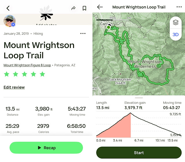
Mt. Wrightson Loop Trail

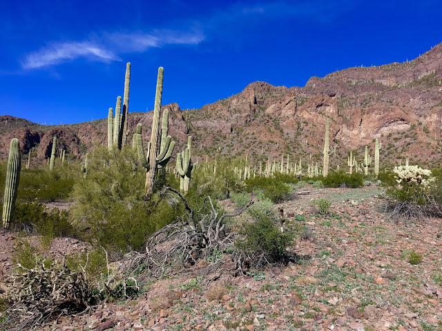
Hard to get a glimpse of the peak at the start of the hike. This might be it, or
a smaller sister near the saddle before the last mile.
Finally got a chance to climb Mt. Wrightson, the tallest peak in the Santa Rita range south of Tucson. Warm temps in the 70s at the base and around 50 at the summit. The last two miles or so were packed snow and ice, treacherous but for my new Kahtoola micro spikes. Saved my bacon on the many narrow, steep switchbacks, where one slip could mean a tumble down a ravine or worse.  

Alas, this was my last hike for the season in the Tucson area, and more importantly, my last hike with my pals Misty and Jack. Thursday, it's on to Bisbee and my old hiking haunts with my good friend Ira.


I will definitely be taking these to my next winter Grand Canyon hike for those icy stretches near the top.
Like most mountain ranges in the Southwest, the Santa Ritas have had increasing numbers of fires, exacerbated by climate change. The last serious fire to sweep through was the Florida fire in 2005 (named after the Florida Peak and Canyon near Mt. Wrightson).


Looking north toward Tucson, about half way up.


Looking south toward Mexico.

More evidence of the 2005 Florida fire.


This gentleman is a strong hiker who lives in Green Valley next door. He hikes Mt. Wrightson at least once a week. His dog Charlene, is not a Border Collie mix as I had assumed, but a ten-month old Large Munsterlander, a German pointer spaniel. Sweet and energetic pooch.

In fairness to us, the summit, while only 5.4 miles, gained over 4,000 feet of elevation on the Old Baldy ascent. Coupled with the packed snow and ice at the top, one can see why it took 3.5 hours to summit.

The Fred Lawrence Whipple Observatory (formerly the Mt. Hopkins Observatory) on the neighboring 8,500-foot Mount Hopkins.


Wisps of smoke but we thought it was probably a controlled fire. Smoke is no laughing matter in this tinderbox land. Oddly, the state has defunded the fire watch stations, preferring to react to fires with federal funds, a typically short-sighted, pennywise, pound foolish act of feckless tax-cutting  Republicans.


Summit selfie, sitting atop the foundational remains of the former Mt. Wrightson lookout. Photo by Jack.
 Stop-action 360º shot from the summit.
Jack has to explore every square inch of a place.

A reminder that the State of Arizona once cared about the national forests.


Even with temps in the fifties, the snow has persisted for a month.

Pretty easy to pick our descending trail out against the hillside.

Still large tracts of forest that haven't yet burned. It's only a matter of time.

Pretty easy trail on the descent, with minimal boulders and zero scrambling.

A talus field seemingly out of nowhere.

Another shot of Mount Hopkins and the Whipple Observatory.

A lovely, almost bucolic hillside.


Misty and Jack. Really going to miss these two highly compatible hiking friends. Jack is off to Tanzania on Friday to hike the 19,000-foot Mount Kilimanjaro. He will return in March after we land back in Iowa, then return to Canada until he returns to Tucson November. Misty just moved to Tucson from Evergreen, Colorado. Hope to see them both next year.


Much faster down than up even though the return was three miles longer.


Friday, January 25, 2019

Picacho Peak from the Hunter and Sunset Vista Trails

Picacho from the I-10, photo stolen from the internet as I forgot to take a Picacho
picture while driving in or back out.
Finally hiked Picacho Peak again after first doing so almost twenty years ago. Nice 70-degree day. I recall that it was much harder then, probably because I was in worse hiking shape and twenty-five pounds heavier. In 2019, this was an easy hike compared what we've been doing thus far. I will say, though, that the steepest sections, which required a system of cables to pull oneself up, and guide oneself down were steeper (but much shorter) than Finger Rock, Pima Canyon, or even Pusch Peak. This trail is also not for the faint of heart.


One of the highlights on this hike was meeting Jasmine Bly, from Florence, Arizona. Jasmine was hiking all the trails on the area. We offered to drive her back to her car if she wanted to join us in taking the Sunset Vista Trail to the north parking area, and she gamely agreed.

Picacho Peak, on the left, from the Hunter Trail trailhead, with the blaring morning sun right behind.


Photo by Jack.

Photo by Jack.

Photo by Jack.


Photo by Jasmine.

Photo by Jasmine.

The three of us, perhaps before we met Jasmine. Photo by Jasmine.

Photo by Jasmine.

First of the cables.


Jack selfie. Jack has vowed not to shave until he completes his summit of Mt. Kilimanjaro in February. Photo by Jack.

Mt. Kilimanjaro in Tanzania.

Looking southwest. Photo by Jack.

Photo by Jack.


Jack on one of his ineluctable side trips to a lookout point.


Our summit is beyond that little outcropping. Photo by Jack.


Jack and Randall hitting the cable climbing section of the trail. Photo by Misty.


Photo by Misty.
Misty and Randall on the less steep cabled portion of the trail. Photo by Jack.

Misty nearing the summit. Photo by Jack.

Jack being arty with his camera. Photo by Jack.

Jack's selfie setup (phone balanced on a rock at the bottom of the climb). Good job. Photo by Jack.

View south from the summit. Photo by Jack. 

Misty on the summit. Photo by Jack.

The I-10 and an itty-bitty hill, from the summit. Photo by Jack.


Misty and Randall on mini-twin summit opposite main summit. Photo by Jack.


Jack at the summit. Photo by Misty.

Take it from the top. Photo by Jasmine.


Misty and Jack.


Misty.


Misty and Randall descending summit. Photo by Jack.

Misty and Randall descendingPhoto by Jack.


Jack emoting, pretending to struggle as he climbs back down—a true con descending.


Jasmine, Misty, and Jack heading down to the Sunset Vista Trail.


Back on solid ground: Panorama including Picacho from the Sunset Vista Trail, with Jasmine and Misty on the right.

Misty and Jasmine, with Jack in the background exploring something or other. There is a reason the peripatetic Jack always racks up a little more mileage than the rest of us: he just has to explore every nook and cranny of any hike. Gotta love his enthusiasm.


Cylindropuntia bigelovii or Teddy Bear Cholla (foreground). Cuddly and painful if you ever rub up against one. Those little spines represent hours of tweezer plucking if you've ever had such an encounter. And they go right through your clothes.


This picture looks a little dirty for some reason.


Photo by Jack.

The Sunset Vista Trail was quite literally a walk in the park. Photo by Jack.

Picacho from the "back" side. Photo by jack.

Jasmine and Misty. Photo by Jack.


Photo by Jack.


Pontatoc Canyon-Finger Rock Loop (Warning: Unofficial)

  I have read two or three AllTrails hike descriptions mentioning a possible new trail connecting Pontatoc Canyon and the Finger Rock Trail,...