 |
Hard to get a glimpse of the peak at the start of the hike. This might be it, or
a smaller sister near the saddle before the last mile.
|
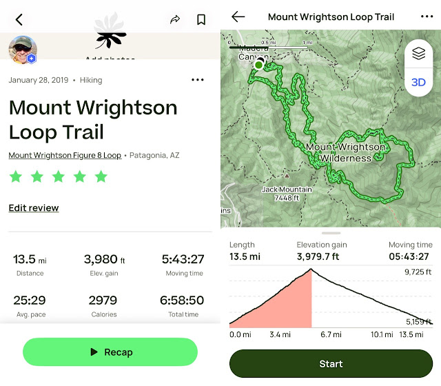
Finally got a chance to climb Mt. Wrightson, the tallest peak in the Santa Rita range south of Tucson. Warm temps in the 70s at the base and around 50 at the summit. The last two miles or so were packed snow and ice, treacherous but for my new Kahtoola micro spikes. Saved my bacon on the many narrow, steep switchbacks, where one slip could mean a tumble down a ravine or worse.
Alas, this was my last hike for the season in the Tucson area, and more importantly, my last hike with my pals Misty and Jack. Thursday, it's on to Bisbee and my old hiking haunts with my good friend Ira.

 |
| I will definitely be taking these to my next winter Grand Canyon hike for those icy stretches near the top. |
 |
| Like most mountain ranges in the Southwest, the Santa Ritas have had increasing numbers of fires, exacerbated by climate change. The last serious fire to sweep through was the Florida fire in 2005 (named after the Florida Peak and Canyon near Mt. Wrightson). |
 |
| Looking north toward Tucson, about half way up. |
 |
| Looking south toward Mexico. |
 |
| More evidence of the 2005 Florida fire. |
 |
| This gentleman is a strong hiker who lives in Green Valley next door. He hikes Mt. Wrightson at least once a week. His dog Charlene, is not a Border Collie mix as I had assumed, but a ten-month old Large Munsterlander, a German pointer spaniel. Sweet and energetic pooch. |
 |
| In fairness to us, the summit, while only 5.4 miles, gained over 4,000 feet of elevation on the Old Baldy ascent. Coupled with the packed snow and ice at the top, one can see why it took 3.5 hours to summit. |
 |
| Wisps of smoke but we thought it was probably a controlled fire. Smoke is no laughing matter in this tinderbox land. Oddly, the state has defunded the fire watch stations, preferring to react to fires with federal funds, a typically short-sighted, pennywise, pound foolish act of feckless tax-cutting Republicans. |
 |
| Summit selfie, sitting atop the foundational remains of the former Mt. Wrightson lookout. Photo by Jack. |
Stop-action 360º shot from the summit.
 |
| Jack has to explore every square inch of a place. |
 |
| A reminder that the State of Arizona once cared about the national forests. |
 |
| Even with temps in the fifties, the snow has persisted for a month. |
 |
| Pretty easy to pick our descending trail out against the hillside. |
 |
| Still large tracts of forest that haven't yet burned. It's only a matter of time. |
 |
| Pretty easy trail on the descent, with minimal boulders and zero scrambling. |
 |
| A talus field seemingly out of nowhere. |
 |
| A lovely, almost bucolic hillside. |
 |
Misty and Jack. Really going to miss these two highly compatible hiking friends. Jack is off to Tanzania on Friday to hike the 19,000-foot Mount Kilimanjaro. He will return in March after we land back in Iowa, then return to Canada until he returns to Tucson November. Misty just moved to Tucson from Evergreen, Colorado. Hope to see them both next year.
|
|
Much faster down than up even though the return was three miles longer.
|


