Tuesday, January 28, 2020

Wasson Peak 2020

Since we’re moving to Bisbee this week, and I won’t be hitting a trail for awhile, I figured I might as well take one more swing at Wasson Peak, the highest point in the Tucson Mountains. My brother Jon and I hiked it last year right after I picked him up from the airport, my way of welcoming him and his 400-foot Texas lungs to Tucson. I took it a little easier on him this year with the shorter but still difficult Pontatoc Ridge Trail.

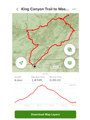
Today’s goal was to shave a few minutes off from last year’s time and finish in 2 1/2 hours. In that I succeeded. I did hike it clockwise  this year, versus counter-clockwise as last year, starting on the Gould Mine Trail, then the Hugh Norris Trail to the peak, and finally, back on the King Canyon Trail. Beautiful day with temps in the low 70s by hike’s end.

Wasson Peak is within the boundaries of Saguaro National Park West. On Saturday, we backpacked in Saguaro National Park East.


The remains of a building associated with the old mine.

Monday, January 27, 2020

Picacho Peak Via the Hunter Trail

It's been 20 years since I last hiked Picacho Peak up and back on the Hunter Trail. I did hike it last year, ascending via the Hunter and descending on the longer and much more gradual Sunset Vista trail, but the Hunter is particularly challenging because of the amazing elevation gain. Thus did I think that a Picacho Peak hike would be the perfect going-away gift for Jon, visiting from Dallas, who flies out in the afternoon. Another perfect weather day, if one ignores the smog, which apparently everyone in Arizona does.


I'm not sure most ten-year-olds could hike this trail. (Photo by Jon Damon)

 (Photo by Jon Damon)

 (Photo by Jon Damon)
 (Photo by Jon Damon)
 (Photo by Jon Damon)


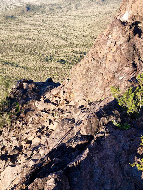
The system of cables that makes Picacho Peak accessible to lay hikers starts in earnest at the saddle.  (Photo by Jon Damon)


 (Photo by Jon Damon)

Jon posing on an outcropping.


 (Photo by Jon Damon)


Straight up.


 (Photo by Jon Damon)

 (Photo by Jon Damon)

 (Photo by Jon Damon)

 (Photo by Jon Damon)

 (Photo by some guy from Wisconsin)

(Photo by Jon Damon)

Saturday, January 25, 2020

Douglas Spring Overnight

After almost five months, I finally got around to my second backpack outing in preparation for my brother Jon and my six-day Grand Canyon backpacking adventure in May. My previous shakedown trip was a little three-day, 26-mile hike up the Pine Creek Trail in Colorado, last August, with my Denver biking/hiking pal, Joel. That led me to believe than an old novice like myself can hike all day with 40 pounds on my back. Perhaps I should start putting bricks in my day pack for the remainder of my day hikes this winter, just as practice. Nah.

Not a lot of great places to hike and backpack in Iowa, so these two overnights will have to stand as my training. Since no leg of our Rim to Rim to Rim hike will be longer than seven or eight miles, we should be okay. The most trying aspect of the R2R2R is the 12,000 feet of elevation gain, and the heat, which will require carrying a lot of water. Jon and I are pretty strong climbers, though, so we'll be okay.

I've hiked Douglas Spring Trail at least as far as Douglas Spring Campground several times, and last year as far as Cow Head Saddle (17+ miles), and last month, all the way to the Tanque Verde Ridge trailhead (over 20 miles). Both of those times I had my 25L day pack with only about 15 pounds on my shoulders, but they were day hikes, not overnights.


Seven+ miles to the campground with our little detour to the Bridal Wreath Falls, for a total of 13.9 miles.
That's a smile, not a grimace under the load as we just donned our packs. (Photo by Jon Damon)

I don't normally hike with poles, but they did seem to help distribute the weight and were helpful crossing the few streams we encountered. (Photo by Jon Damon)

Bridal Wreath Falls.  (Photo by Jon Damon)

 (Photo by Jon Damon)


 (Photo by Jon Damon)

Surprised to see the manzanitas blooming.  (Photo by Jon Damon)

Looking north toward the Santa Catalinas.

Due east, also in the Rincons.

Looking south toward Tanque Verde Ridge. That was the second leg of an epic nearly 21-mile hike early last month.

(Photo by Jon Damon)


Break time.


(Photo by Jon Damon)

Not bad for a backpacking effort.
Camping permit firmly attached. We were camping next to five rather noisy scofflaws who didn't bother to register with the park service. Pretty shameful as it’s only 8 bucks per site.


Jon and his new tent.


Camp site with bear box on the right.

Maiden voyage for my new Big Agnes inflatable mattress and Sea to Summit pillow. Nice to finally get a decent night's sleep while camping. Jon used my old Thermarest, which he seems to enjoy.

Two other new additions to camping: a Stanley flask (full of tequila), and powdered margarita mix, which Patty found for me at R.E.I. I bought the titanium double-walled mug several years ago for forty bucks. Now they're priced like fine crystal (well, $50).


First use of the new MSR Pocket Rocket, a tiny stove with big power, boiling a liter of water in under three minutes. Dinner consisted of Asian noodles, a pass for the next trip. I usually stay away from anything so generally named as Asian, and should have this time as well. (Photo by Jon Damon)

This GSI tea kettle holds 2.8 liters and, when packing, my fuel, stove, and stand. R.E.I. of course
Cocktail hour. The sun sets around 5:45 this time of year, so early to bed. 

Not sure I have ever been in bed for 12 hours straight, but it got pretty cold that evening and we waited until the sun was almost up before we arose. (Photo by Jon Damon)
Nothing like morning camp coffee and, in Jon's case, camp tea.
 (Photo by Jon Damon)

Ready for the trip back to the trailhead.

 (Photo by Jon Damon)


 (Photo by Jon Damon)

A couple of miles to go. (Photo by a stranger, in this case a park ranger.)

Pontatoc Canyon-Finger Rock Loop (Warning: Unofficial)

  I have read two or three AllTrails hike descriptions mentioning a possible new trail connecting Pontatoc Canyon and the Finger Rock Trail,...