Thursday, February 16, 2023

Cactus Forest Trail (Das Boot Rant)

◊Scroll to the bottom for an update.◊

Perhaps you're thinking that this blog post is about more than just a hike, and you'd be correct. While I did need a moderate (easy, in this case) hike as a warmup for Saturday's more consequential outing, I also needed a comfortable hike on which to break in a new pair of boots. This little 10-miler in Saguaro National Park East seemed to fit the bill. 

Note: Before I continue with this post, which really isn't about the hike so much as the boots, I hiked this trail about a year ago and wrote it up here.

It seems I am hard on hiking boots. That is one reason that I plonked down several hundred dollars last year to purchase an amazing pair of old-school all-leather Danners, made in Portland and completely reconstructable—perhaps the last pair of boots I'd need, considering my already advanced age. However, I haven't worn them on a hike yet, preferring to use my Southwest-specific boots I already have that have really shown the wear and tear this rocky terrain metes out. I also think the Danners are better suited to hikes in places like Oregon, Washington, and Colorado, where trails are more forgiving, and one is more likely to encounter mud and gravel and pine needles, not rocks, boulders, and shards of schist. So I've basically consigned myself to hiking in disposable boots as long as I continue to hike in Arizona.

I have been wearing Vasque hiking boots and shoes since I began Arizona hiking some 9 years ago. They have always felt comfortable right out of the box (until now), and held up fairly well, considering what I put them through (also until now). 

I bought a pair of Vasque Breeze boots in late 2019 in preparation for my solo six-day 60+ mile Grand Canyon backpacking trip the following May. That trip was canceled due to Covid so I wasn't able to make that trip until May of last year. Meanwhile, I hiked about 4 months in the new Vasques, including a weekend backpacking trip in Colorado. That iteration of the Basque Breeze pretty much wore out after five months. I wrote Vasque a letter with photographs of the boots, and after sending them back at their request, I received a new pair in the mail within a week. That is the latest pair I almost completely destroyed in six months of Arizona hiking. 

Last week, I ordered a pair of the more robust Vasque Talus, which REI had on sale. Those are the boots I wore today as well as the boots I'll be returning tomorrow. I guess I am no longer a Vasque guy. After only 10 miles, I developed nascent blisters in at least two spots on each foot—not a harbinger of long-term comfort.


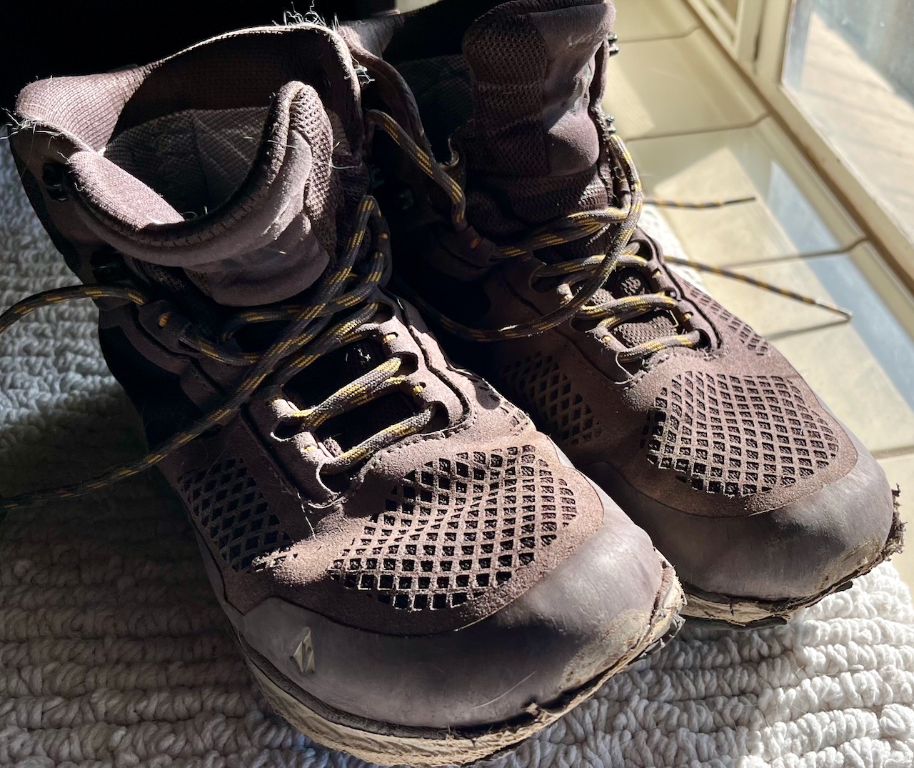
The Vibram sole of each boot has completely worn through to the under-footbed.


Not the quality one expects from a brand whose parent company is Red Wing. 


These are the replacement boots. This is after the hike and after I cleaned them up. REI will be able to sell them in their used gear site, with only a very slight reduction in price.


Meanwhile, back on the trail. This sandy, flat trail bed is why I chose this particular hike. Easy on the feet; easy on the boots.


Tanque Verde Ridge in the background. I was planning on hiking up that challenging 15+ mile route in the Rincons this Saturday. That might now be off the table.


This is the replacement I decided on, the Keen Circadian mid waterproof hiking boot (and 20% off at REI). It felt great in the store, and two days after this 10-mile hike, where I tore up the ball of my right foot, and the heel of the right, I did a strenuous 14-miler up Tanque Verde Ridge and back. While the places on my feet that suffered from the Vasque tryout still hurt, overall I think I'm happy with them; the Keen's wide last, especially the toe box, fits my Frodo feet quite well. And they seem very durable. Only time will tell.


Tuesday, February 14, 2023

Sarasota-Explorer-Sunset Pass Trails

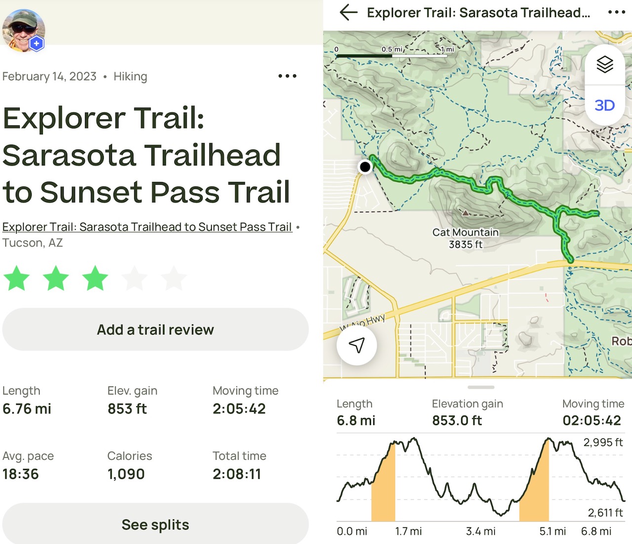
With a cold front moving in, and the wind picking up around noon and taking the sun with it, I needed a short hike to tide me over until Thursday, the next decent hiking day. I also need a little training for a long, challenging hike on Saturday. This little six-miler fits the bill nicely. The trail is rated as moderate, but I would downgrade that to the cusp of moderate & easy. As an added bonus: I've never hiked it before. On the trail by 9:00, and done by 11:00. Temps around 45º at the trailhead, around 55º two hours later, with a considerable uptick in wind speed. 

The trails on this hike are in Pima County's magnificent Tucson Mountain Park, itself in the Tucson Mountains, a minor range just west of Tucson. This park is an Arizona treasure and, along with the adjacent Saguaro National Park (West), has helped to preserve the land from the rapacious local developers. On a slightly optimistic note, Pima County has stopped issuing permits for single family residential buildings; too little too late, in my opinion, but with the water crisis and the climate catastrophe in full throes, better than doing nothing. 

From the Pima County website:

About the Park

Tucson Mountain Park was established April 1929. The Pima County Parks Commission, with C. B. Brown as its chairman, was established to oversee the park. At approximately 20,000 acres, the park is one of the largest natural resource areas owned and managed by a local government in the U.S. The park has approximately 62 miles of non-motorized shared-use trials. The park’s trails are open to hikers, equestrians, and mountain bikers, and provide a wide range of outstanding experiences, including technical challenges, and breathtaking views. Gates Pass overlook includes interpretive displays and historic structures. Picnicking and wildlife viewing opportunities are located throughout the park.

I have hiked one other trail in the park, The 13-mile David Yetman, a favorite morning hike I have done several times, most recently in December, 2022.

This hike is supposed to be 5.6 miles, but I added a mile when I 
stayed on the Explorer Trail not realizing AllTrails wanted me
to take the Sunset Pass to the end (bottom tine of the fork above).
I must say, the Explorer Trail was far more interesting than the
Sunset Pass trail, which passes close by a detritus-laden housing
development.


The Sarasota Trailhead.


This hike started on the Sarasota Trail (black) to the Explorer (pink) and finally, the Sunset (orange).


Ran into a gaggle of older folks, and passed another.


Encroaching suburbia, the bane of all that is sane.


Friday, February 10, 2023

Seven Falls Trail to Hutch's Pool to Phoneline Trail

Epic hike today.

The plan was to suggest to my hiking partner Misty that when we got to the junction of the West Fork Trail to Hutch's Pool, we add the 3-mile spur to our existing 18-mile hike. Knowing Misty's love of uber-long hikes, and love of a challenge, I already knew she'd agree—and of course she did. So we ended up close to 21 miles for the day, and a glorious one it was, despite the wind blowing up through Bear Canyon past Seven Falls.

We were somewhat worried about the high winds starting out. Ostensibly out of the east-southeast, when these atypically strong sustained winds hit the canyon, they swirled, converged, and eddied into a 20-mph headwind for the first five miles. What was amazing is after we climbed up out of the canyon to the grasslands above and headed west, and for the rest of the day, the winds blew straight out of the east, and greatly diminished, blocked by the very mountains in which we hiked. 

We had a total of 20 river crossings today as the rains of December and January, which are stored as snow on the peaks of the Catalina's, continue their early spring melt and fill the streams and washes and pools. 

I first hiked the Bear Canyon Trail to Seven Falls over 30 years ago—when Sabino Canyon was just developing—and again in 2017. That is little 8-mile affair with modest elevation gain. It wasn't until last year, however, that Misty and I hiked past Seven Falls to do the 18-mile Seven Falls-Phoneline loop. This hike is actually comprised of four trails: Bear Canyon, East Fork, Sabino Canyon, and Phoneline. Today, in a paroxysm of hiking optimism (we both like to test ourselves), added yet another trail to the hike: the three-mile roundtrip spur on the West Fork Trail to Hutch's Pool. 

Beautiful day, high forties starting out, rising to seventy by hike's end. Encountered very few other hikers, a few trail runners close to Sabino, and a large group of hikers doing a point to point from Gordon Hiraybashi Campground on Mount Lemmon taking the Sycamore Reservoir Trail to Bear Canyon.


.

Most of the trails in Sabino Canyon Recreation Area start out on a paved tram road.


Misty, successfully staying dry on the first of 14 
stream crossings in Bear Canyon this day.


Misty got some great shots of my elderly rock-hopping
self. It's amazing we were able to stay out of the drink 
today. Nothing worse than hiking 20 miles in wet boots.

And one more...


Seven Falls.


I have never seen this much water in the Catalinas.

The Bear Canyon Trail meets up with the Sycamore Reservoir Trail to Mount Lemmon after about 6.5 miles.


This is where we made the decision to add three miles to our journey, to take the West Fork trail west to Hutch's Pool. It actually ended up being only 2.5 miles as the water was so high that the final stream crossing before the pool was treacherously high. And so we contented ourselves with the lower reaches of the Pool.


Misty on the lower end of Hutch's Pool.


Even the Ocotillo was green during this most wet Tucson winter; climate change writ verdant.


Hugh Norris Trail to Wasson Peak 26

Today, we hiked the 10-mile Hugh Norris Trail to Wasson Peak, which also has around 2,400 feet of elevation gain.  I hiked extra hard today ...