Wednesday, January 3, 2024

Catalina State Park to Sabino Canyon

We had talked for years about combining two of our favorite hikes into a point-to-point: Hutch’s Pool and Romero Canyon. We finally made it happen. And to do so required hiking from Catalina State Park off Route 77 up in Oro Valley, to the Sabino Canyon Recreation Area on the northeast side of Tucson—to the tune of over 20 miles. The logistics were a hassle, getting up early and parking cars at both locations. But what a beautiful and varied hike. Plus, we got to see a birds-eye view of  Hutch’s Pool and discovered the springs that feed it. 


The hike was also marked by several river crossings—over 40 in all, across mostly dry beds—and two sides of a range that could hardly be more different. Romero Canyon, with it’s steep assemblage of rocks and boulders and switchbacks, and an elevation gain of 4,000 feet over 7 miles; and the West Fork Trail side, with smooth sandy paths wending their way down a  gentler slope for 13 miles, more reminiscent of Colorado wilderness than Arizona. And what a relief after the hard scramble up Romero; our feet were grateful.


Both sides of the hike still showed signs of the massive fire that swept through and burned 120,000 acres in these Santa Catalinas in June of 2020. Lots of burnt-out hulks of oak and fir and cacti. The trails themselves were in great shape, and clearly the park services (federal and state) have been busy with maintenance. 


Hit the trail at 7:00am while it was still dark, with the temperature a brisk but calm 38°, which would top out at 67° for the day. 


This elevation graphics the right really sums up the hike.

Video preview of the hike provided by All Trails.

Map of route (black line) , sans final four miles through Sabino Canyon.


Started out cold and dark. I had to use a headlamp for the first mile or so. Great hiking weather.


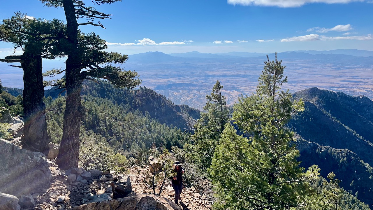
Looking down on Oro Valley, something I often do.


First glimpse of the Romero Pools. Did see a camper and his son with an illegal fire. Freedoms!


Minimal water feeding the streams and pools, which mostly are relying on springs during this dry month.


One of my favorite campgrounds on this hike.


One last push up to Romero Pass.


Where we're going.


Where we've been.


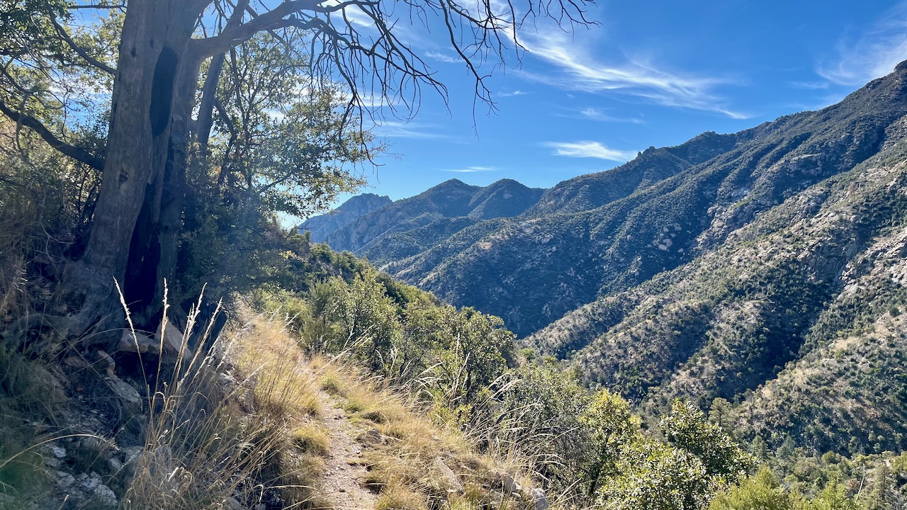
We will take the West Fork Trail (#24) over past Hutch's Pool to the Sabino Canyon trail.


Already liking the look of these trails as my dogs are barking from the rugged Romero Canyon.


(Photo by Misty Atkins)


Another option wold be to hike up to Cathedral Rock and back down via the Esperero Trail, which we made the mistake of taking last season from Ventana.


Apparently, God herself placed this boulder here around 6,000 years ago, when she was busy making this place.


First glimpse of Hutch's Pool, or at least the spring which feeds it.


A better view of the pool, which is pretty low compared to last year, when we couldn't reach it from the east due to high water. That was another epic hike of 20+ miles.


Our idyllic lunch spot.


The last leg, the Sabino Canyon Trail, which would prove to be as rocky as Phoneline and Romero, much to the chagrin of our put-upon feet.


Wednesday, December 27, 2023

Phoneline to Blackett's Ridge and Saddleback

Finally made it out to Sabino Canyon and my favorite "training" hike, Blackett's Ridge: short (6 miles), steep (1,700 feet of gain, mostly over 1.7 miles), and sweet (easily accessible, as it's in town). The goal with this hike, and why I liken it to a training hike, is that it is doable in roughly a couple hours (sans the 20 drive to and fro). It is a bit of an ass kicker, when hiked with gusto, but has lots of rewarding views. 

This holiday week, there were a lot of other bipeds out—as I've come to expect on weekends and holidays—leisurely gaggles of friends and families trying to burn off their over-indulgences.

Clear, calm (wind around 3 mph), and cool today, barely nudging 60º by hike's end. Perfect hiking weather.


This AllTrails 3D hike preview is a new feature. Testing to see if it's worthy.


The first ¾ mile or so is flat dirt trail, and then trolley road.


Saddleback is the actual destination, after traversing first the Phoneline trail, and then the Blackett's Ridge trail.


This hike is known for its plethora of false summits, five or six in all. And even the terminus is a false summit as there is no summit on this hike—just a small saddle.


Thursday, December 21, 2023

Joe's Canyon to Miller Peak

Beautiful day for hiking just prior to a massive rain front moving in tomorrow, rendering the upper elevations less hike-able. 

Because of the front moving in that will dump copious amounts of snow at elevation, I decided to revisit my beloved Huachucas Range near Sierra Vista to introduce my hiking partner to a couple of favorite hikes: Joe's Canyon and Miller Peak. Temps around 70º at the base of the range, around 50º at Miller summit. 

This hike really kicked my butt today, perhaps because I haven't yet acclimated to the elevation, but also perhaps due to the distance (17 miles) coupled with the elevation gain and rockiness of the Crest Trail. However, my times were not too far off from my previous visit nearly four years ago.

This mountainous U.S.-Mexican border area, remote and challenging to traverse, has always been a favorite place for desperate people crossing into the U.S. Unfortunately, the neo-fascist Maga Republicans have begun their eco-destruction of the once-pristine landscape by building new roads and walls to placate their racist supporters. What was once a porous barbed wire fence that allowed for the necessary movement of people and wildlife, has been replaced by a steel fence that is killing other animals in search of food and water, and forcing immigrants to cross the border in even more inhospitable and dangerous places, often perishing in the effort. As early as 2015, my pal Ira and I used to hike right down to the border on the Yaqui Trail spur off Joe's Canyon Trail, cross over the border into Mexico for lunch, and hike back out all without worry. In 2017, I even led a Muleteam hike down for lunch in Mexico during the first year of the orange one's reign, on a day his head of Homeland Security visited and flew over the area in a Border Patrol helicopter. Now this terminus of the 800-mile Arizona Trail has been rendered unwelcoming to the peoples of both countries.


Unnecessary new sign erected by the fascist and racist Trump administration.


Joe's Canyon.


Grassy ridge leading to Montezuma Pass, from where we will start the Crest Trail to Miller Peak.


Saw a few mule deer today.

New road construction at the terminus of the Yaqui Trail segment of the Arizona Trail. Note the wall section popping up over the slope from the west. This wall is a replacement for a barbed wire fence. 


My friend Ira standing on the Mexican side of the fence, February, 2015. We often had lunch on the hill in the background.


This commemorative stele re-establishing the treaties and border with Mexico. This has now likely been removed.

Looking west from our Mexican lunch spot. This is the fence line marking the U.S.-mexican border as it once was.


The many mountains (cerro) of Mexico.


Misty.


One of the amazing walls on this trail, this at around 8,500 feet, probably built by the CCC during the 30s.


Halfway point and summit. Really not a bad speed considering how steep and rocky the Crest Trail is.


View fromMiller peak.


Panorama video from the summit.

One of many dead sentries from the massive fire from 15 years earlier.


Front Window

Scroll down for new videos. Now for a tortured segue between my last post—from February 10—and today’s. Last time out I reported completing ...