Friday, February 25, 2022

Blackett's Ridge in Two

I chose this short yet difficult hike as my last of the season for two reasons: it's relatively close by and would fit in my three-hour window; and I wanted to beat my old time of 2:15 which I could have done the last outing here but for my trip and fall and the loss of my phone that forced me to hike back up to the summit in vain to look for it. I really wanted to get my time down to about two hours, but that might be considered folly by many of my hiker pals.

As I did on the previous hike, I made it to the summit in a little over  
an hour, boding well for  beating my previous time. However, the
hike down is slow going, made more so today by the large number
of other primates climbing up whom a descender has to wait for.


Not bad, but not quite two hours. damn those twelve seconds.


Tuesday, February 22, 2022

Bug Springs Trail

Today is the last real hike of the season, real for us meaning not a stroll on a flat trail shorter than eight miles. The Bug Springs Trail turned out to be a bit of a workout, but getting the blood moving was essential with trailhead temps in the high thirties. And the first 2 miles or so were pretty much all up hill—to the tune of over 1,400 feet of elevation gain. 

This trail is in the eastern end of the Santa Catalinas, about twelve miles up the Catalina Highway on Mount Lemmon. The last hike we started off this highway was earlier this year when Misty and I hiked the wonderful Soldier Trail. And three years ago, four of us would ride our bikes all 26 miles up to the summit of Mount Lemmon for the thrilling and frightful 40-mph descent. Maybe once is enough for that journey, not only because of the insane descent, but done as it was on a heavy 30-year-old Klein mountain bike with shocks that don't lock out.

Glad we hit the trail early today (7:30) as we avoided other bipeds until the last couple of miles from the end. Temps were in the sixties when we returned to the trailhead after three and a half hours.

The Bug Springs Trail has some interesting and varied ecology and geology. We started out on a pretty smooth trail punctuated by the occasional boulder scramble. After the ascent to the first saddle, we climbed down into the canyon and through a wonderful forest of oaks, aspens, and fir trees—on any other hike or later in the day a welcomed respite from the heat, but today, we pushed the pace to get back into the sun.

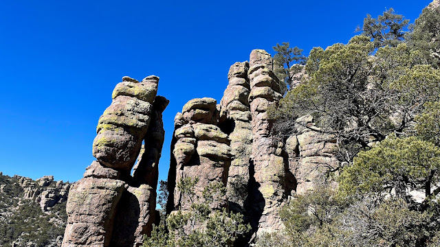
The geology was also somewhat varied today, but this trail is known for its rock outcroppings and spires. Who knew hoodoos would feature in two consecutive hikes—and hoodoos of completely different origin. The hoodoos on Mount Lemmon are primarily metamorphic, and primarily gneiss; the hoodoos from last week's hike in the Chiricahuas are mostly extrusive igneous rhyolite rocks, the result of extreme volcanic activity. In both cases, the shapes of these columns of stone are formed over millions of years through the processes of erosion common to these arid climates: freezing and cracking in the winter, and the slow abrasion of wind and water across geologic time. 


Much of the trail, but especially the ridges, was forgiving sand and gravel. My feet thank you, Bug Springs Trail.


Misty with her usual sun-drenched smile.


Scar of a prior fire, not the horrific blaze of 2020, which burned over 120,000 acres in the Catalinas.


A look toward the forested canyon down into which we would shortly descend.


Pushing the limits of my iPhone's telephoto function.


About two miles and half an hour from the end of the hike. (Photo by Misty Atkins)

Gneiss shot.


Tuesday, February 15, 2022

The Big Loop to Heart of Rocks

The Big Loop hike in the Chiricahua National Monument strings together half a dozen trails, including the Heart of Rocks loop, to create a nice little 9.5 mile (15.4 km) hike, with moderate elevation gain. We lucked out with clear weather temps in the 60s, despite the elevation of 5,000-7,000 feet. Very windy, however, and the protections of the deep canyons were a godsend.

The monument was established in 1924 to protect the vast collection of hoodoos (stone columns) and balancing rocks. The extensive trail system was built in the 1930s by the Civilian Conservation Corp as part of the New Deal Era Work Relief Programs. These trails consist of many laboriously-constructed dry stack stone walls and steps—quite the engineering feat—with the help of hundreds of CCC workers.

The geology is the result of a massive volcanic eruption 27 million years ago that laid down a 2,000 foot layer of rhyolitic tuff, containing fairly soft siliconized pumice that eroded into the present-day formations.

The loop starts out counter-clockwise on the Echo Canyon Trail, followed by Upper Rhyolite Canyon, Sarah Demming, Heart of Rocks, Big Balanced Rock, Inspiration Point, Mushroom Rock, and Ed Riggs trails.


Hoodoos standing at attention, for me reminiscent of the terra-cotta army created for the tomb of Qinshihuang, the first emperor of China.


Good place for an ambush.


Soaking in that great sun. (Photo by Misty Atkins)


Yet another great place to take down an unsuspecting cowboy.


Heart of Rocks panorama.


Camel Head Rock.


Just finishing up the stunning Heart of Rocks.


This impressive rock gets its own sign.


Inspiration Point, where we had lunch.


Amazing trail work, with lots of dry stack stone walls and steps.


Hugh Norris to Wasson Peak

After Saturday's epic twenty mile hiking event, I needed something a little shorter to end my season. Having already established a tradi...