Monday, January 31, 2022

Aravaipa Canyon Trail

When my hiking partner Misty asked if I'd like to hike 10 miles up a canyon, crossing a stream dozens of times in 40+ degree water, in temps ranging from 35º-60º, I admit I was a little skeptical. I tend to like my feet dry and my shoes devoid of sand and gravel when I hike. But I survived, and after the shock of the first few plunges, and despite water nearly up to the knee at times, I actually got used to it and enjoyed myself like any other hike. The canyon turned out to be stunning, and to our surprise, completely devoid of other bipeds. This is a permit area (they give out 30 passes a day), but despite being only an hour from either Tucson or Phoenix, nary a soul would we see today.


The sun rising at the trailhead and parking lot.


Some stretches leave you no choice but to hike in the stream.


This massive limestone up cropping would soon reveal itself.


Great little campground and our lunch spot, with an amazing backdrop.


Getting ready to head back after lunch.


Back at the parking lot in time for the clouds to roll in. I will say, I would hate to be caught out in a monsoon rain in this canyon. No where to run, no where to hide. And the debris we saw spoke of several gushing floods well over our short heads.


My soaked feet. I thought these water shoes would work but the traction was horrible, the support non-existent, and at the end, the pain palpable. They will be returned.


Tuesday, January 25, 2022

Mount Kimball Via Finger Rock and Pima Canyon Trails

I try to do at least one hard hike a week, as opposed to moderate. These are actual trail designations and they can be subject to, well, subjectivity, and they're also pretty generalized. There needs to be degrees within each category. For instance, today's hike was not only hard, it was really fracking hard. While only 10 miles round trip, the real killer was the elevation gain after the first kilometer or so: around 1,000 feet per mile. And it's rocky and in places dangerous as well, especially when wet. But we had glorious weather, albeit a bit chilly in the morning because of the shade from the slowly rising sun.

I have hiked to Mount Kimball previously, in 2019 with my hiking partners Jack and Misty. That was a point-to-point hike coming up Pima Canyon Trail and coming down Finger Rock Trail—arguably easier despite being longer because of the steepness and rockiness of the Finger Rock Trail compared to Pima Canyon, which is itself steep and rocky.

And this wasn't my first ascent of the Finger Rock Trail. I hiked it up to Linda Vista Saddle twice, in 2018 when it was wet and treacherous, and again in 2019. We saw no hikers past Linda Vista Saddle, and very few before, except in the last mile on our return. The trail is still listed as closed on AllTrails so that probably cut down on the more serious hikers.


The gods decided to highlight Finger Rock as I approached the parking lot at the end of Algernon Way.


A closeup of the offending digit.


The trail starts out with a stream crossing or two and a nice flat trail surface. After about a mile in, however, it really gets steep.


Linda Vista Saddle, about 3 miles in.


The intersection with Pima Canyon Trail, which we'll take to Mt. Kimball. Not sure where Finger Rock Trail goes from here (probably connects to the Ventana Canyon Trail) , but not to Finger Rock, which merely lent its name to the trail because of it's proximity, as far as I can tell.


It's stark to see these pictures next to pictures from before the fire of 2020 swept through the Catalinas and left a lot of burnt forest.


Our lunch spot on Kimball overlooking Oro Valley, and Pusch Peak among other landmarks.


Photo taken through my Peakfinder app.


Friday, January 21, 2022

Agua Caliente Hill

When I hike alone, like I did today, I prefer a relatively well-trafficked hike in case I have an elder incident, stroke out, and collapse in a heap on the trail because, "just what the hell do you think you're doing at your age!?" This trail fits the bill for that, though most hikers don't do the whole grueling 9 miles. I did know what I was getting into as I hiked this trail once before, in December of 2019.

Right away the trail starts its 3,000 foot ascent, reserving the steepest and rockiest bit for the last half mile when you're knackered. But it's a relatively accessible hike, out on Tucson's eastern periphery, a small mountain (it is called a hill) plunked down between the Santa Catalinas and the Rincons. It will get your heart rate up, get your glutes whining, and get the dogs barking from all the rocks and the pounding. 

But the Agua Caliente offers a lot of scenic variety, and it's a great way to kill a morning sans other primates. I did, however, run into a group of four just-retired postal employees at the summit. These guys were younger than me by a bit, and were surprised to know I'd been retired almost 11 years (June, 2011. Yes, I am what Mitt Romney and other plutocrats would call a taker.). I have always thought having a mail carrier route would be great for getting in hiking shape, and apparently I was right.


Hit the trail about 8am, temps around 40º, which would rise to the low 60s at the summit.


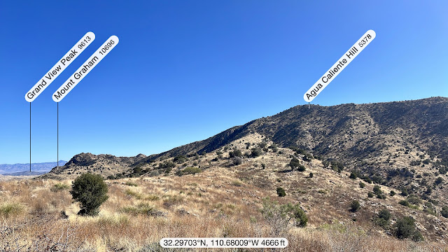
First glimpse of Agua Caliente Hill (according to my excellent hiking app, Peak Finder—highly recommended).


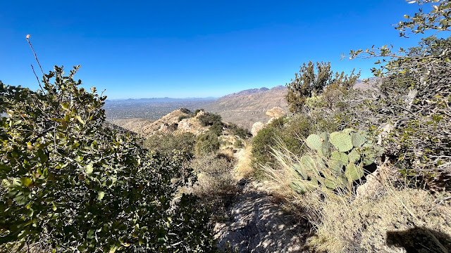
View of the trail after leaving the summit.


Remnant of the Cat Track Tank water reservoir, 1.7 miles from the trailhead, taken on the return with better light.


Hugh Norris to Wasson Peak

After Saturday's epic twenty mile hiking event, I needed something a little shorter to end my season. Having already established a tradi...