Friday, December 30, 2022

Wasson Peak Via Sweetwater Trail

I was initially waitlisted for a hike up Wasson Peak today with my Meetup hiking group, Baja Arizona Hikers. I found out too late that I was added to the hike by organizer and self-proclaimed "usual suspect" Bill. B., so I planned my own Wasson hike. 

Misty joined me even though she's been under the weather; and Misty under the weather is stronger than many a hale hiker. We chose a different trailhead—starting on the Sweetwater Trail versus the King Canyon Trail—so we wouldn't interfere with the Baja group, already a rather robust 12 hikers. Oddly, Sweetwater is considered a hard hike at 9.3 miles, and King Canyon moderate at 7.8 miles. But quite frankly, I think both hikes are moderate. Misty and I also did this hike a year ago with our friend Jack from Quebec, and his friend Danny, also French Canadian.

We ran into the Baja Hikers at a saddle and the confluence of the Sweetwater and King Canyon trails. Old hiking pal Stan, and Bill B. (both strong hikers) were there, as were a couple of other strong hikers we'd hiked with previously: Mark and Belinda. They led the Tortolita Superloop hike with me and Misty in January of 2020


Beautiful morning. Hit the trail shortly before 9:00, with the temp was around 50 degrees, on its way to 60º.


Our destination.


View from the summit looking back from whence we'd come.


A bit windy and cool at the top, requiring the donning of a jacket. (Photo by Misty A.) 


Misty on the far left in blue. I am in the orange jacket (front left) noshing on a chocolate chip coconut oatmeal cookie (using mesquite flour) made by fellow Baja hiker David (middle of frame). Absolutely delicious and I am pressing him for the recipe. (Pic by Bill B.)


Tuesday, December 27, 2022

David Yetman Trail

Post holiday, and hiking solo, I needed a short, safe, not terribly challenging hike to ease into the new year and work off Sunday's potluck with friends. The Yetman trail fits the bill nicely: under 13 miles, well-trafficked trails, and only 1,300 feet of elevation gain.

Another plus today, I saw no people starting out at 8:30, and few on the way to Gates Pass, where the trail ends and I reverse my steps. Temps around 52º starting out, climbing up to 72º at the finish on its way to the high today of 77º.

The historic Bowen House remains had nary a soul, save mine, and I'm pretty sure I don't have one as they don't exist. Usually, even on weekdays, since Bowen House is so close to the trailhead, it's rife with other apes. I would encounter a few bikers and hikers today, but mostly on my return from Gates Pass.


The beautiful Bowen House, built in the 30s, and abandoned a couple of decades later.


I took advantage of the lack of people to take the pictures I've always avoided because of the people.


The Yetman trail is but one of many in the wonderful Tucson Mountain Park, which has somewhat saved the area from the rapacious developers that haunt Arizona like parasites.


The Bowen house is always a welcomed sight on the return as it means you only have a mile left to go.


Thursday, December 22, 2022

Hutch's Pool Via Phoneline and Sabino Canyon Trails

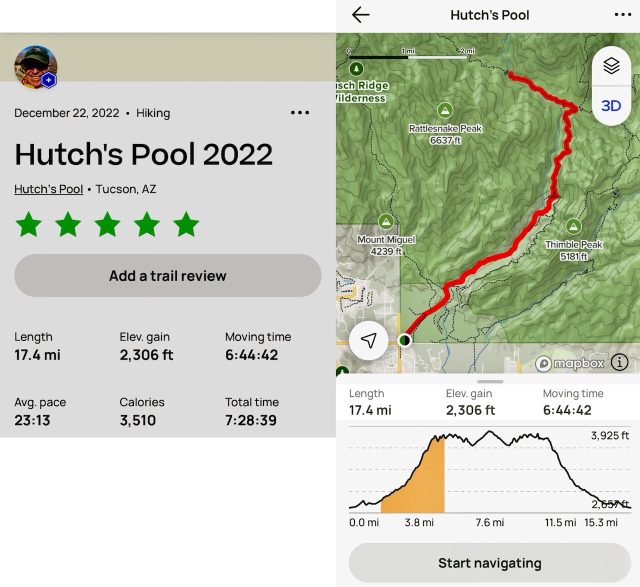
Hutch's Pool is a favorite hike, and today's gorgeous weather—clear skies and mid-sixties—only made it more special. I was joined by my uber fit hiking partner Misty Atkins, late of Colorado, now of Tucson. This was our second time on this hike together. We also did it about three years ago with our friend Stan, which came in at 18 miles (18 because we got off trail to the tune of half a mile).

AllTrails rates this hike as moderate, perhaps because their route has you walk the paved shuttle road for the first three+ miles, and again on the return. Yet other hikers take the shuttle bus to the Sabino Canyon trailhead shaving another 7 miles off the total.We chose to hike the parallel Phoneline Trail, which increases the distance from 15.3 miles to over 17, and also increases the elevation gain by 500 feet. That said, I'd probably still rate this hike as moderate because of the relatively low elevation gain of 2,300 feet.

We were in for the whole experience today: Phoneline, Sabino Canyon and the West Fork (Sabino Canyon) Trails, out and back. After we got past the Phoneline Trail and onto the Sabino Canyon section, we saw no other hikers until we returned to the Phoneline. I'm not sure why there have been relatively so few hikers this season; we've noticed it on other trails this year as well, including on the weekend. My theory is that peak pandemic had folks out in droves clogging up the trails, and now they're taking some time off as they return to their normal lifestyles. In any event, I'll take it. Hiking, for me, is like watching a movie in a theater; I'm not wild about sharing the space with lots of strangers. 

One last thing, I’m now (temporarily at least) wearing a Medicare-“gifted” Fitbit, a rather pestiferous appliance with all the constant notifications (most of which I managed to turn off). Today’s hike came in at just under 44,000 steps. Whoopty.


The shuttle bus which travels the 3.5 miles from the visitor center to the Sabino Canyon Trailhead and back every half hour from 8:00 AM to 4:00 PM.


The West Fork Trail took us to the Pools. It continues on to meet up with the Romero Canyon Pass and Trail, which we did a couple of weeks ago. The East Fork wraps around over to Bear Canyon. Last year Misty and I did an epic 18-mile loop hike up Bear Canyon, past Seven Falls, and around to the Sabino Canyon and Phoneline trails. A wonderful hike I'd certainly do again.


Ms. Atkins.


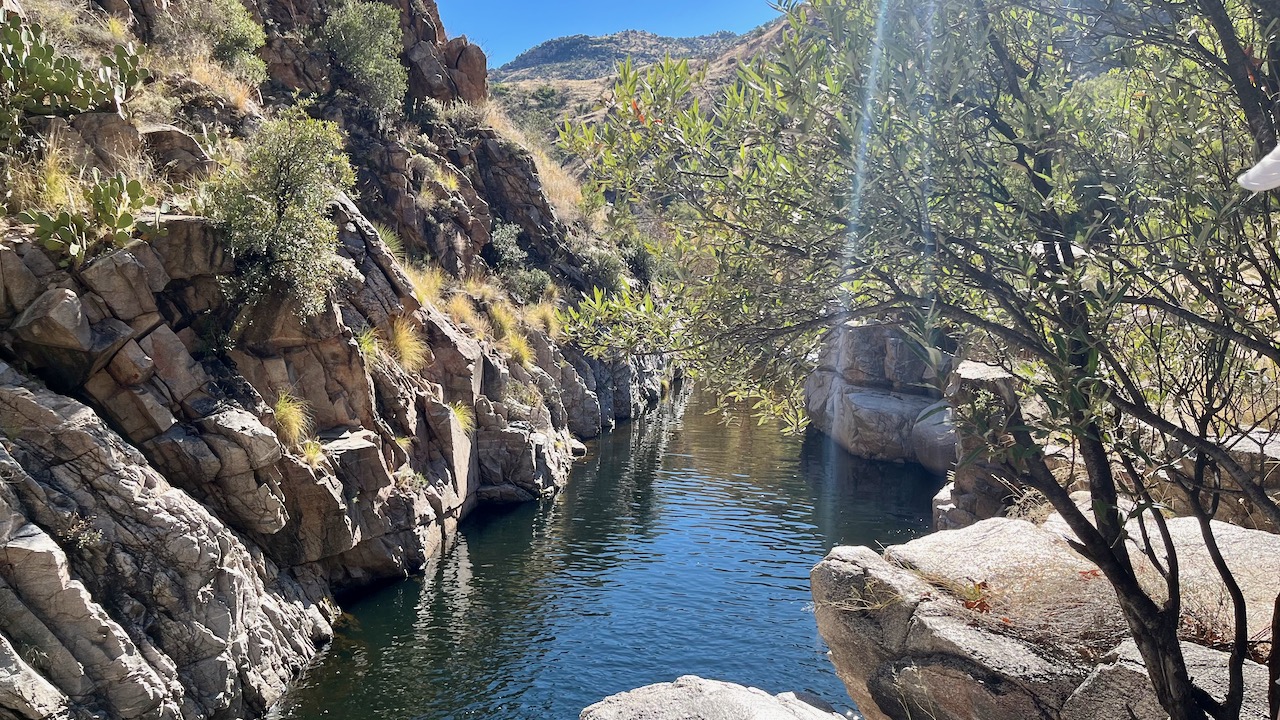
The Pools. There are camping spots out here, and usually campers.


Lots of water this year.


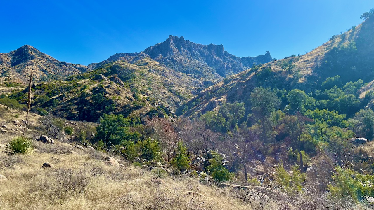
Still a lot of fall color in Sabino Canyon.


I love these massive layer cake boulders.


Saturday, December 17, 2022

Tortolita Superloop

Today's hike in the Tortolita Mountains was nearly four times as long as  Thursday's hike at over 16 miles, but lucky for me, only twice the elevation gain. This is my second time hiking the superloop; I also did it in January of 2020, with some very fit 30-40 something hikers from a local Meetup group. What it also had in common with the last hike is herds of aggressive animals on the trail (well, last time there was just a warning sign, no actual animals). I also saw a rare crested saguaro (more on that later).

Beautiful day. Highs got up to in the 50s, up from 32º starting out. Kept a pretty decent pace throughout. Started out mostly climbing, but after four or five miles, the hike leveled out on ridge trails. [Click the pic to continue on the blog]


This clumsy hike name is AllTrail's concoction. Those of us who know 
this hike call it simply the Tortolita Superloop. Tortolita means little turtle
dove in Spanish.


The Superloop is composed of all the perimeter trails on this map: Wild Burro, Alamo Springs, Ridgeline, Loop, Wild Mustang, and the Upper Javalina trails.


One starts out with a 1,000 foot rocky climb up, just to get the heart going, and the ankles potentially twisted.


The afore-mentioned aggressive animals I encountered: a 15k trail racing primate on the left (one of 20 or so), and a bicycling biped on the right (maybe a dozen all told). 


A cristate or crested saguaro. These are quite rare mutations, and  acanthochronologists (cactologists, if you will) disagree on what causes them; some say freezing and lightening strikes, others say a hormone causes the pleats to grow out of control. 


This wind-driven mill was retrofitted with a solar panel and the
blades removed. It's used to pump water into a tank for a horse trough.


The Wild Mustang Trail portion was devoid of bikers, and almost devoid of hikers save one I ran into.


Hugh Norris to Wasson Peak

After Saturday's epic twenty mile hiking event, I needed something a little shorter to end my season. Having already established a tradi...